history

Historical background
Friday, 10 November, 2006 - 14:43

The area was originally settled by Bushmen (San) and Hottentots, but towards the end of the 17th century they were gradually displaced by the Hlubi people wandering down from KwaZulu-Natal, led by a woman named Xhosa. These people claimed a common ancestry with all the tribes of the eastern coast, originating from a place called eMbo. When the Xhosa encountered the Hottentots, they were much taken with the clicks in the Hottentot language, which became a fashionable part of the Hlubi language.

Successive waves of people came down the coast and began to split up into homogenous groups. The northern group became the Pondo, the middle group became the Mtembu and the southern group became the Gcaleka.

Pressure from migrating tribes in the north pushed the population southwards where they began to encounter the white traders and settlers moving north. The inevitable result was conflict.

The first half of the 19th century were particularly turbulent years. The reign of Shaka was sending shock- waves down the coast as refugees from his wars came pouring south in search of new homes. This led to many differences of opinion between the residents and the newcomers. The British, moving north, often intervened in these tribal wars and also found themselves in wars of their own. The result was the nine Frontier Wars. It was at this time that a young girl called Nongqawuse had a vision that her forebears would help the Xhosa drive the English out. The disastrous result weakened the Xhosa still further. Matters were not helped by the fact that the Xhosa themselves were not an homogenous people ?? there were a number of old and newly-formed tribes in a shifting demographic landscape and often they fought amongst themselves.

The Ninth Frontier War spelled the end of the Xhosa and the Transkei area was incorporated into the Cape Colony. But it was never quiet. There were raids between settlers and Xhosas, and turf wars between different Xhosa tribes. Missions were established here and there to try to bring Christianity to the people, with limited success.

Because of the warlike reputation of the region and the ongoing tensions between the different factions, the place was never really populated by European settlers and was thus left largely to the indigenous people.

Version II:

History of Pondoland (Transkei)

The land of the Pondos is full of stories that remind us of times gone by. Most of these tales are kept only through their telling but some have been recorded.

Somewhere between 500 and 1200 years ago Bantu speaking people settled all along the East coast of Southern Africa down to what is now known as Port Elizabeth. This area was also home to nomadic San and Khoi people. Many of the Khoi were incorporated bringing with them the three characteristic clicks that are found in the Xhosa language today.

This region is geographically referred to as "Eastern Pondoland".

The amaPondo are one of 12 Xhosa speaking tribes. The Pondos and other Xhosa speakers along the coast had their first contact with Europeans in the form of shipwrecked sailors. Strange light-skinned apparitions would occasionally be left with the white foam on the beaches after a big storm. The Xhosa word for "Whities" is "Abelungu" - meaning just that - 'foam from the sea'. Some of the shipwrecked stayed - the clan name 'Umlungu' often recording the history of their children.
Trade between the amaPondo and other Xhosa speakers - where Xhosa tobacco and cannabis was traded for metal - has been dated to 400 years ago. Trade between the Xhosa and Boers was recorded 300 years back.

Around the late 1700's the pressure for land began increasing. For the Xhosa speaking tribes there were the British to the South, Boers to the East and other Bantu speakers from the North. Those from the North were pushed down by the series of battles and migrations that were set off by the rise of Shaka and the Zulu state. The war with the British and the Boers continued sporadically for 60 years. By the early 1850's relations between the Cape Colony and the so called 'Territories' had settled down to an uneasy peace. This standoff was tragically settled by the 'cattle killing' of 1856. On the advice of a diviner (Nongqawuse), people were ordered to eat all their cattle and consume or destroy all their crops. All those who disobeyed together with all whites were to be swept into the sea by a strong wind on the 18th of February 1857.

At this time there was an abundance of cattle and grain, but with the resulting famine, resistance to the colonials crumbled. In the same year the British introduced a poll tax. By 1858 all chiefdoms except those of the Mpondo had submitted to colonial administration.

Geographically remote, tucked away in the far NE of the 'Territories' the Pondos were furthest away from the wars with the colonists. They did not take part in the cattle killings of 1856 and were exempt from the poll tax of '57.

The Pondos had been effected by the Mfecane - the wars and migrations set off by the rise of Shaka and his Zulu empire. In 1828, during the reign of Faku (paramount chief of the Pondos), they lost their land and cattle east of the Mzimvubu (river) to many hundreds of people who were fleeing Shaka's impis (warriors). It is during this retreat that Faku reorganised his military forces and intensified raiding, hunting, agricultural and trade enterprises. By 1843 the Pondos had replaced their herds of cattle and Faku represented many people living south of the Zulu kingdom, commanding tremendous power. The following year Faku signed a treaty with the Cape Colonial government which recognised and protected his authority. Many groups of people joined his empire as a means of protecting their land from the 'trekkers' in Natal who were keen to expand their own borders.

Through various political, economic and religious pressures the tribespeople were forced to accept the annexing of Pondoland to the colony in 1894.

For 70 years Pondoland fell under the Cape Provincial Administration - first under British colonial government and then from 1948 under the Nationalist party government. The 'separate development' policies (Apartheid) of H.F. Verwoerd resulted in the 'awarding' of 'self-government' to an area known as the Transkei in 1963 (The area known as the Transkei incorporated many, though not all, of the Xhosa speaking tribes.) This was followed by 'full independance' in 1976.

After the first fair democratic elections in South Africa in 1994, the Transkei as an entity fell away, and the region became part of the vast and diverse Eastern Cape. Despite this incorporation, Transkei in general and Pondoland in particular remain discrete regions in many ways.

Many people still lead lives not much different from those of their ancestors during the 16th and 17th centuries. Traditional forms of land use and government are still practised, and while this may be partially explained by the shortage of facilities and capital during colonial and apartheid governments, the resilience of many craft, religious and other cultural practices also suggests a determination on the part of many rural people to retain elements of their heritage. This does not mean that modern ideas and innovations are rejected; instead they are incorporated and employed alongside traditional methods."

Janet Hayward (Research in progress)

Version III:

The Pondoland region was occupied by hunter gatherers from about 500,000-150,000 years ago, with agropastoralists establishing themselves in the area in the 7th century AD. People have thus had an impact on the local environment for many centuries (Feely 1987).

By the nineteenth century, the area was used extensively for cattle grazing. Settlements at that time were mostly temporary and only from 1894, after the annexation of Pondoland and subsequent large scale immigration into the area did grazing occur year round (Beinart 1982).

The area was then subject to regulations and restrictions from different governing bodies: the British colonial authorities (1894-1910), the Union of South Africa (1910- 1963), the Republic of South Africa (1963-1976), the government of the Transkei homeland (1976-1994) (Southall 1982) and more recently the provincial Eastern Cape and national government structures.

From the turn of the century to about 1930, cattle numbers increased significantly and since have varied much less with declines due to drought or government destocking regulations in the 1960s (Kepe and Scoones 1999).

... Read more
Xhosa King Mpendulo Zwelonke Sigcawu
Friday, 21 October, 2016 - 08:01

Xhosa King Mpendulo Zwelonke Sigcawu (1968) was the 12th King of the amaXhosa nation.

He was succeeded by King Ahlangene VULIKHAYA Sigcawu in  Oct 2020.

Details :-
King of the Xhosas (Gcaleka & Rharhabe)
Reign 1 January 2006 to 14 November 2019
Coronation 15 May 2015
Predecessor King Xolilizwe Mzikayise Sigcawu
Born April 4, 1968 
Nqadu Great Palace, Willowvale
Full name Zwelonke Calvin Mpendulo Sigcawu
House of Phalo
Father Xolilizwe Mzikayise Sigcawu
Mother Queen Nozamile Sigcawu
Zwelonke Sigcawu (1968 - ) was the 12thKing of the amaXhosa nation. Zwelonke was born as Mpendulo Sigcawu to Xolilizwe Mzikayise Sigcawu and Queen Nozamile.
Information Credit > https://en.wikipedia.org/wiki/Zwelonke_Sigcawu 

... Read more
Towns of historical interest in the 'kei
Saturday, 9 June, 2007 - 16:30

Butterworth
Butterworth is the oldest town in the Transkei, built quite near to the place where the great chief Hintsa had his palace. It was founded by Methodist missionaries in 1827. The Xhosa name is Gcuwa after the river running through it, but the English name is from the then- treasurer of the Wesleyan Mission Society, Reverend Butterworth. At the end of the Frontier Wars – during which the town had been burnt down three times - traders began to settle here. During the days of 'independence' it was earmarked as a site for industrial development but most of these ambitious projects have now been abandoned.

Umtata
Until quite recently Umtata (Mthatha) was the capital of the independent homeland of the Transkei (which was established in 1976 and de-proclaimed in 1994). Its name was changed to Mthatha in 2004. Numerous government buildings were built in the latter quarter of the 20'th century which fell into a certain amount of disrepair after the government departments were relocated to Bhisho following reincorporation into South Africa in 1994.

Founded in 1871, it also houses a City Hall, built in 1908 with a beautiful garden, the Bunga (Parliament) dating from 1929, and a fine Anglican cathedral.

The Bunga was originally built to house the Transkeian Territories General Council, which was superced in 1956 by the Transkei Territorial Authority. This governance framework of the rural areas, with its councilors representing the many tribes throughout the territory, continued throughout later years when the TTA was superceded in 1963 when Transkei gained nominally autonomous self-governance, and again in 1976 when it was granted nominal independence. 

The Nelson Mandela Museum is now housed in the Bunga building. The museum is divided into three sections – the central section traces Madiba’s life by means of photographs, write-ups and displays. The other two rooms display the extraordinary gifts given to him during his life, from all over the world.

There is an open-air swimming pool and some interesting craft projects, such as Izandla pottery, Ilinge Craft and the Ezibileni Industrial Centre.

The founder of the town was Richard Calverley who in 1868 was granted land on the west bank of the Umtata River by Ngangalizwe, chief of the Tembus, to provide a buffer zone between the Tembus and the Pondos who were perpetually at war. There were many skirmishes between these two tribes until the respective chiefs decided to grant farms along the Mthatha River to European settlers in order to establish this buffer zone. One of the early settlers was the Bishop H Callaway, who built a sizeable settlement on his farm which laid the foundations for the modern town. By 1884 the town had grown to 140 buildings, mostly of wood and iron, with several shops. The European population was then already 500, excluding the military. 

There is some controversy about how Umtata got it's name. One school of thought holds that the name was given by a tribe in the region of the Khambi Mountains who used to commit their dead to the river saying 'mthathe Bawo' (meaning "take him Lord"). Others maintain that the name derives from the sneezewood tree (umtati) which, it is generally conceded, grew abundantly on the river banks and ravines in the early days. Indeed, one of the earliest missionaries in the Transkei, describes a journey to the Tambookie chief, Depa, in 1827 and says: "The Umtati, or Sneeze Wood River, is the largest we crossed today. And that should settle the matter. (Adapted from "The Transkei and its Places" by H.L. Potgieter (MLUNGISI) - 1960.)

Port St Johns
Port St Johns is a laid-back haven for backpackers, artists and travelers, drawn by its bohemian atmosphere and languid sub-tropical vibe. For more info visit [www.portstjohns.org]

Hole-in-the-Wall
 was named in 1823 by Captain Vidal of the Barracouta – one of the ships in an expedition sent out by the British Admiralty to survey the coast. Coffee Bay The bay got its name in 1893 when a ship full of coffee beans ran aground here. Some of the beans took root and grew into little coffee shrubs - but the soil and climate proved too wild and inhospitable for the plants to survive.

Kentani
Known sometimes as Centane, this tiny centre only has a population of a few hundred people, but a huge history. It was the site of the final battle of the Frontier Wars between Xhosa and settler in 1878.

The battle itself was as tragic as any in South Africa’s many wars. 5 000 Xhosa warriors had been told by their witchdoctor Xito that he had made them impervious to bullets. Therefore they stormed a fort manned by less than a thousand colonial troops and were mown down by heavy fire. Three thousand warriors died, with a loss of only two of the English forces.

The Xhosa strength was spent, the chiefs surrendered and the area became the nucleus of the present Transkei.

Willowvale The town has a population that numbers only in the few hundreds, but also played a rather pivotal role in Transkei’s history. It was in this area that the local Xhosa split into two factions in 1950. The senior section remained in the Willowvale area while the split-off group moved to the south, beyond the Kei River. The British invaded the land of the Gcaleka in 1837 and settled 40 000 Mfengu tribesmen in the area.

Immediately trouble broke out between the residents and the new settlers, which led to the Ninth and final Frontier War in 1877. The Xhosa were defeated at the Battle of Kentani and the bulk of the Gcaleka people were driven north. This, combined with the decimation of the Xhosa people after the prophecy of Nongqawuse, led to the area becoming almost completely de-populated.

The little mission station that had been built at Willowvale and named after the row of willow trees behind the mission, was abandoned.

Idutywa
 was established as a military fort in 1858. Its name, which means 'place of disorder' is particularly apt as it was first settled after a dispute between local people and a raiding party from KwaZulu-Natal. .

Viedgesville (Jojweni) is a tiny village that is noteworthy only as a turn-off point for the coastal resorts.

Qunu
Thirty kilometres north of Umtata is the scattered little town of Qunu, which has the unequalled claim to fame of being the birthplace of Nelson Mandela. His 'palace' can clearly be seen from the N2, and he has had a tunnel built under the road so that school-children could cross the road in safety.

The neighbouring hamlet of Mveso is where he spent the first two years of his life. The Mandela Museum runs free tours on the area. If you book in advance, a Xhosa dinner will be cooked for you.

Mazeppa The bay is named after a ship that used to land goods here in the 1930's. A little island connected to the mainland by a suspension bridge provides a good vantage point for fishermen.

Of interest are numerous middens left behind by the prehistoric beachcombers (strandlopers) that used to frequent the area.

Lusikisiki
This little village is very close to the seat of the Paramount Chief of East Pondoland. The name comes from the sound that the reeds make when they rustle in the nearby river. The most obvious activity in this little town surrounds the labour recruiting offices for the Johannesburg Gold Mines.

In his book, 'Discovering Southern Africa', TV Bulpin records a delightful picture of life in Lusikisiki: 'A long central street provides an animated spectacle of tribespeople in their national costume doing their shopping or gossiping in the shade of the store's verandahs. The men (often riding into town on horseback) attend to their business at the offices of the government.'

Sadly, this was written in the 1970's and the picturesque scenes that Bulpin describes are no longer there. People no longer wear their national costumes and their preferred mode of transport is now a motor vehicle.

Flagstaff
This little trading town has a colourful history. In 1875 two traders obtained a concession from the chief to open a trading store on this spot. The store was instantly successful – so much so that the two traders found it difficult to keep people away when they closed on Sundays or holidays. So they erected an extremely tall flagstaff right next to their store and flew a white flag on the days when the store was closed. This served the dual purpose of warning their customers that they were closed and gave the town its English name.

The Xhosa name is Siphageni.

Kei Mouth
This quiet little village consists of a few stores, a post office, cottages and holiday homes on the slopes of seaside hills. From Kei Mouth there is a outboard-motor driven pont (car ferry) to get you across the river and into the Wild Coast.

... Read more
Xhosa Calendar
Saturday, 9 June, 2007 - 11:45

The Xhosa months of the year are poetically named after stars and seasonal plants of Southern Africa. The Xhosa year traditionally began in June and ended in May, when Canopus, the brightest star visible in the Southern Hemisphere, signalled the time for harvesting. In urban areas today, anglicised versions of the months are used, especially by the younger generation. But in the rural areas of the Eastern Cape – the old names still stand.

  • January - EyoMqungu (month of the Tambuki Grass)
  • February - EyoMdumba (month of the swelling grain)
  • March - EyoKwindla (month of the first fruits)
  • April - uTshaz'iimpuzi (month of the withering pumpkins)
  • May - EyeCanzibe (month of Canopus)
  • June - EyeSilimela (month of the Pleiades)
  • July - EyeKhala (month of the aloes)
  • August - EyeThupha (month of the buds)
  • September - EyoMsintsi (month of the coast coral tree)
  • October - EyeDwarha (month of the tall yellow daisies)
  • November - EyeNkanga (month of the small yellow daisies)
  • December - EyoMnga - (month of the acacia§ thorn tree)

§ Update: December was listed incorrectly as the month of the mimosa thorn tree. But as mimosa is not indigenous to South Africa, and only would have arrived here a few hundred years ago from South America; December should actually be the "month of the acacia thorn tree". Oxford English-Xhosa Dictionary backs this up. 

~Jeff - Oct '16

... Read more
Ships wrecked
Thursday, 12 April, 2007 - 21:56

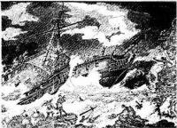
The Wild Coast partly derived its name from its wilderness character, but mostly from the pounding breakers and cauldron of its boiling seas when stormy conditions reign. This particular part of the Eastern Cape coast has been the graveyard of many a ship through the ages, and ship’s skeleton, artefacts and structures bear mute testimony to the loss of lives and vessels.

Most of these wrecks vanished beneath the waves and have been forgotten, yielding up nothing but an occasional small treasure for the beachcomber. Some are still visible as rotting hulks lying in shallow water, like the Jacaranda at Qolora Mouth or the Idomene at Qora Mouth. Some have left a legacy – the name of Coffee Bay supposedly comes from a ship that was wrecked in the bay with a cargo of coffee beans. It is said that the beans grew into short-lived coffee bushes that gave the bay its name.

Stranded Ross Craft - photo by J. Costello 
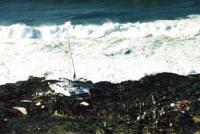
Some have left their names – it is believed that the name Port St Johns comes from the wreck of the sixteenth- century Portuguese ship Sao Joao. Mazeppa Bay’s name comes from one of the apparently few ships that made it – the British ship Mazeppa often used the bay for anchorage and survived to tell the tale. But the most famous wreck of all is that of the English ship, Grosvenor.

Her tragic end came on August 4th 1782, while on a return voyage from India. She ran aground then sank in a very deep gully off a rocky little bay called Lwambazi. Although only 14 of the 150 people on board drowned, just six sailors reached safety at a frontier farm near Port Elizabeth. News of the disaster prompted the colonial government to send an expedition to rescue the survivors. They only found 12. For many years, however, rumours persisted of the 'un-found' survivors living with local tribesmen, and an expedition in 1790 discovered a colony of about 400 people of non-African descent living on a tributary of the Mngazi River. These were the sad remnants of the various shipwrecks along the coast.

Photo by J. Costello
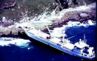
The expedition found no trace of the Grosvenor. In the meantime, however, another legend had arisen: that the ship had been carrying a fortune in bullion and silver. One of the rumours insisted that the fabulous Peacock Throne of Persia (a royal chair made of solid gold with peacocks outlined in precious stones, and which had been looted round about this time) had been smuggled on board.

What followed was an absurd and costly series of recovery schemes, many of which cost more than any reputed treasure on board the ship. Steam-drive cranes, suction dredgers, undersea tunnels, boulder breakwaters, high-pressure water- jets, explosives, mining efforts – even a group of spiritualists led by a ghost – made no impression whatsoever. Only two cannons and several gold and silver coins have ever recovered from the wreck of the Grosvenor. It lies there still, in its dangerous little gully, its secrets hidden by treacherous currents and drifting sand. What treasure is on board, and how to get to it, no man knows.

---------- Of historical importance at Mkambati (and tourist interest) are two famous shipwrecks, namely the Sao Bento(1554)- near the mouth of the Msikaba River - and the Grosvenor (1782) lying in Lambasi Bay.

... Read more
Nongqawuse
Thursday, 12 April, 2007 - 21:46

1856 was a bad year for the Xhosa nation of the Wild Coast.

Their lands had been taken by the British, drought had withered their crops, and their prized cattle were dwindling under a mysterious disease.

The people were facing a hard winter when hope came in the shape of a young girl called Nongqawuse, the niece of a prophet. Nongqawuse claimed that the spirits of the ancestors had spoken to her from a pool in the Gxara River.

If the people would only kill all their cattle and burn their crops, a day would come when new cattle and crops would arise along with an army of the ancestors who would drive the whites into the sea.

The "vision" took hold among the desperate people, who followed her orders.

By February 1957 more than 200 000 cattle had been slaughtered and left to rot. All the summer crops had been burnt.

The allotted day dawned and nothing happened. The weakened population began to starve and within a few months more than a third of the entire Xhosa people had died of starvation and disease.

It was easy for the British to take over the remnants of the tattered Xhosa kingdom and imprison the chiefs for their role in this ??genocide??.

Nongqawuse was taken to Robben Island for her own safety but her people were broken.

The 1856 cattle killing has receded into legend and its tragic manifestation is Nongqawuse's pool, which can still be seen on guided tours from the resort of Qolora Mouth on the Strandloper Coast.

See http://en.wikipedia.org/wiki/Nongqawuse for more info.

... Read more